Crawford land in Cooper County, Missouri
Last updated May 23, 2004
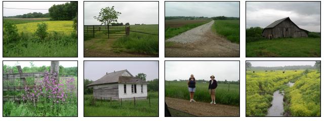
Photos taken during trip by Nancy, Sharon, and Jim on May 12, 2004
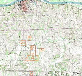
The following USGS map shows the relationship of Boonville to the Crawford lands, which are outlined in orange.
Initials used here and in the lists and map below:

  JEC or JC - John Edward Crawford
  GC - EC   - George Crawford - Elizabeth Crawford
  JLC - NTC - James L Crawford - Nancy T Crawford
  HT - JT   - Hetty Thomas - John Thomas
  NC - JCh  - Nancy Chambers - Joseph Chambers
  MR - WR   - Margaret Reid - William Reid
  JCg       - John Crawford [son of George Crawford]

  JEC, GC, JLC, HT, NC, and MR are all siblings
The following listing is for land patents obtained by the Crawfords in Cooper County.
    Property        Thoma-date Acres  Patent-date     Name
    --------        ---------- -----  -----------     ----
NWSE   S24 T48 R17  10/16/1832  40    09/30/1835 John Edward Crawford
SWSE   S24 T48 R17  11/09/1834  40    06/15/1836 Hetty Thomas
NESE   S24 T48 R17  08/16/1836  40    08/10/1841 Hetty Thomas
S1/2SE S19 T48 R16  03/20/1837  80    01/10/1840 John Crawford**
E1/2SE S25 T48 R17  09/15/1821  80               George Crawford & William Reed
NE     S25 T48 R17  09/27/1822 160               George Crawford & William Reed
W1/2SE S25 T48 R17  09/27/1822  80               George Crawford & William Reed
SESE   S24 T48 R17  08/24/1835  40    11/02/1837 William Reed
E1/2SW S25 T48 R17  12/03/1836  80    01/10/1840 George Crawford
SWSW   S25 T48 R17  12/03/1836  40    01/10/1840 George Crawford
W1/2NE S1  T47 R17              81.72 01/10/1840 George Crawford
W1/2SW S30 T48 R16              63               George Crawford

** This must be John Edward Crawford, not George Crawford's son, because
   according to W. F. Johnson's book, George's son lived at home until he
   was married, which was not until 1848.
Property is in the format: Quadrant Section Township Range
("NWSE", means Northwest quadrant of the Southeast quadrant, whereas
"S1/2SE" means the Southern half of the Southeast quadrant).
The "Thoma Date" and the last four entries are data transcribed by James
F. Thoma and taken from the web at:
http://www.rootsweb.com/~mocooper/Land/Land_Records_T4817.htm.
The rest of the data comes from the GLO land patent site:
http://www.glorecords.blm.gov/PatentSearch/.
The following listing is a summary of deeds found in various Deed Books in the Cooper County Court House in Boonville. It is not complete (e.g. index was not searched for Thomas, Reid, Chambers, Savage, or McCormick).
    Property       Acres  Price  Date    Book-page   Names
    --------       -----  -----  ----    ---------   -----
W1/2SW S30 T48 R16         $250 01/21/1822 B-p158 GC & EC --> Henry Bonsfield
E1/2SE S4  T47 R17  80     $129 01/07/1831 D-p8   James McCormick <-- Joseph Cathey & Hannah
E**    S25 T48 R17              08/13/1832 D-p68  GC & EC and WR & MR
S1/2SE S19 T48 R16  80     $200 10/30/1839 G-p350 JC   --> Henry Bonsfield
SENW*  S25 T48 R17   1      $20 05/26/1845 K-p262 GC  <--  William Gartner & Kissiah

E1/2NE S1  T47 R17  81.72  $400 01/23/1846 2-p117 GC   --> JCg
NESE   S1  T47 R17  40     $360 01/28/1852 2-p117 JCg <--  George W Baker & Harriet P

E1/2SW S13 T48 R17  80     $250 04/01/1833 ?-p179 JLC <--  Littleton Seat & Elizabeth
NE     S23 T48 R17 115.95  $330 03/00/1839 G-p469 James Crawford <-- John Anderson & Eleanor
NE     S23 T48 R17 115.95 $1200 10/06/1852 2-p159 JLC & NTC -> Isaac Lionberger

** joint land split up so George gets W1/2SE and the part of
   W1/2NE west of the meandering stream, and William gets the rest]
*  SE corner of property 43 yards wide
The following USGS map shows sections 24 and 25, township 48N, range 17W
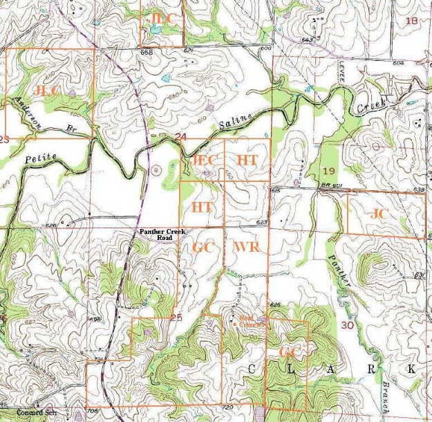
and sections 19 and 30, township 48N, range 16W. The orange boundary lines are only approximations. "Reid Cemetery" is at the orange square. The dirt road actually extends up the ridge to the top; the cemetery is a few feet west of the road by two trees just after it passes a gate after an old barn.
Click here to see a recent, large aerial photo including most of the above map.
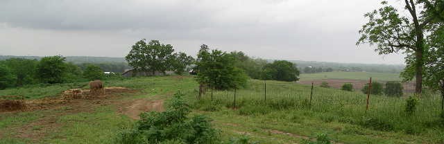
Reid Farm looking north taken ~100 yds a little east of south from Reid Cemetery. The graves surround 2 trees: the large (maple?) tree in front of the gray barn, and the spruce tree that sticks up in a line with the corner of the fence, mostly obscured by the big bush. There is a third, shorter tree in the photo between the other two trees; it is actually along a fence separating the cemetery land from the barn area.